• Frost Advisory for Rollins - Click for Details
    ...FROST ADVISORY IN EFFECT UNTIL 7 AM CDT THIS MORNING...
    Expires: May 14, 2026 @ 7:00am
    WHAT
    Temperatures as low as 33 will result in frost formation.
    WHERE
    Central and North St. Louis County. This includes the Tribal Lands of the Bois Forte Band, Nett Lake and, Lake Vermilion areas. Other locations including Voyageurs National Park. This also includes the Boundary Waters western area.
    WHEN
    Until 7 AM CDT this morning.
    IMPACTS
    Frost could harm sensitive outdoor vegetation. Sensitive outdoor plants may be killed if left uncovered.
    PRECAUTIONARY/PREPAREDNESS ACTIONS
    Take steps now to protect tender plants from the cold.
  • Fire Weather Watch for Rollins - Click for Details
    Expires: May 15, 2026 @ 9:00pm
  • Flood Advisory for Rollins - Click for Details
    ...FLOOD ADVISORY NOW IN EFFECT UNTIL 345 PM CDT FRIDAY...
    Expires: May 15, 2026 @ 3:45pm
    LOCATION
    WHAT...Flooding caused by rain and snowmelt continues.
    INFO1
    WHERE...In Minnesota, northwest Cook, northern Lake and northeast St. Louis Counties.
    INFO2
    WHEN...Until 345 PM CDT Friday.
    INFO3
    IMPACTS...Minor flooding in low-lying and poor drainage areas, rivers and around area lakes. Some low-water crossings may become impassable.
    INFO4
    ADDITIONAL DETAILS... - At 254 PM CDT Monday, elevated river and lake levels continue. - This includes the following streams and drainages... Moose River, Jeanette Creek, Horse River, Basswood River, Kawishiwi River, and Hustler River. Additional rainfall amounts up to two tenths to three tenths of an inch are expected over the area through mid-week. Expect high, fast moving water on area rivers and elevated lake levels. Water levels are near or above those seen during flood events in Spring 2022 and June 2024. Areas near the end of the Gunflint Trail and near Ely will continue to see slow decreases in elevated water levels this week. For areas near and on Basswood Lake, flows are peaking as of Sunday afternoon, May 10, and at Lac La Croix peak flows are expected this week. Those venturing into the Boundary Waters should prepare for high water and possible inundation of portages and campsites, as well as dangerous rapids and very cold water. - Some locations that will experience flooding include... Gunflint Lake, Snowbank Lake, Basswood Lake, Boundary Waters Canoe Area Wilderness, Fall Lake, Sea Gull Lake, Saganaga Lake, Ensign Lake, Disappointment Lake and Lac La Croix. - Flood safety information can be found at
    PRECAUTIONS
    Campers and hikers should avoid flooded trail crossings. If camping at a site along or near the banks of rivers or streams, move away from those locations and seek higher ground. Portage and hiking trails may be impassable and low
Listen Live

On Air Now

Lake Effect
Lake Effect
Midnight - 6:00am

Current Weather

Black River Revue

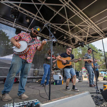
Hardworking bluegrass and Americana quartet Black River Revue just might be the region’s ultimate summer festival band. The sound is as sweet and warm as a July canoe paddle on Bear Head Lake and many shows are staged outdoors after the mercury hits 80. In 2023, the group scored billings at the Great Northern Squash Fest outside Superior, Boats and Bluegrass in Winona, Fresh Hop Fest in Two Harbors, and Klocktoberfest in Grand Rapids. Black River Revue is Adam Stariha on guitar and harmonica, lan Kvale on bass, Nate Hynum on mandolin and Tim Leutgeb on banjo.

Audio

Video